University of Maryland Center for Environmental Science
Understanding Spatial Variability of Water Quality to Promote Seagrass Restoration Success
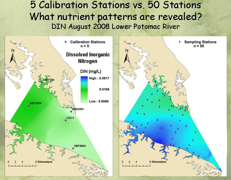
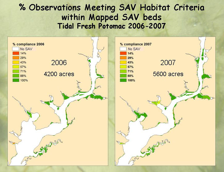
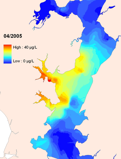
Water quality is a major factor that can limit the successful growth of submerged aquatic vegetation (SAV). A goal of this work is to evaluate potential opportunities to restore seagrass in the Chesapeake Bay, by identifying locations where water quality conditions consistently meet SAV habitat needs. Using monthly data collected using a ship-based sensor, supplementary data, and GIS models, we create detailed spatial maps of water quality parameters and screen for acceptable habitat conditions through time. The spatially intensive sampling techniques provide an opportunity to understand fine-scale variability within the system which is relevant to identify areas for restoration (click thumbnails for larger images).
These spatially detailed data are also being used to build statistical models to test how the drivers of water quality conditions vary in space. Due to the hydrodynamics of the Bay, some areas appear to be more influenced by distant activities that deliver nutrients and sediments to the Bay while other areas appear to be more influenced by local activities such as land use. The relative influence of distant and local activities may vary throughout the year. Enhancing our understanding of the relative influence of distant and local controls on water quality will improve our ability to identify which management activities will be effective at improving local conditions.
Other information and reports about this project available here.
Interpretive Reports from the Gonzo Group:
Report 24 [2007] - "Water Quality Assessment of the Patuxent River Estuary using DATAFLOW: Spatial Interpolation Methods and Interpretation of SAV Habitat Requirements," chapter 5, pp. 95-117.
Report 25 [2008] - "Spatially Intensive Shallow Water Quality Monitoring of the Potomac River," chapter 2, pp. 24-48.
Report 26 [2009] - "Spatially Intensive Shallow Water Quality Monitoring of the Potomac River Estuary," chapter 2, pp. 20-58.
Report 27 [2010] - "Water Quality & Habitat Characteristics of Littoral and Pelagic Zones using Spatial Datasets," chapter 3, pp. 43-96; "Dissolved Oxygen (DO) Criteria Attainment Analysis for Shallow Water Habitats Using ConMon Data Sets," pp. 96-106.
Report 28 [2011] - "Spatial Analysis of Water Quality Conditions," chapter 4, pp. 88-122.
Bush
Corsica
Magothy
Severn